
Embark on a captivating journey through the diverse and breathtaking geography of British Columbia, Canada’s westernmost province. Prepare to be enchanted by the province’s stunning landscapes, from the majestic coastal mountains that rise dramatically from the Pacific Ocean to the rugged, snow-capped peaks of the Rocky Mountains. Discover how these geological wonders have shaped the region’s natural resources, environmental zones, and remarkable ecological diversity.
Delve into the influence of the mighty Pacific Ocean, which has carved the province’s dramatic coastline and formed the intricate network of valleys, rivers, and islands that make up this captivating land. Explore the lush, ancient forests that stretch across British Columbia, home to a wealth of flora and fauna, and meander along the winding waterways that have long been the lifeblood of the region.
Witness the tapestry of landscapes that make up British Columbia, from the fertile valleys to the snow-capped peaks, each region offering its own unique character and natural bounty. Uncover the wealth of natural resources that have sustained the people of this province for generations and learn how the land’s ecological diversity is carefully balanced and protected.
Join us as we explore the captivating geography of British Columbia, a land of unparalleled natural beauty and wonder.
Unveiling the Diverse Terrain of British Columbia
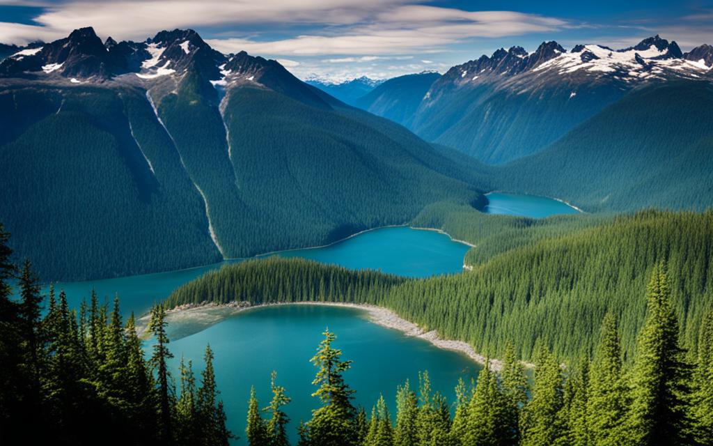
Nestled along the Pacific coast, British Columbia boasts a tapestry of captivating landscapes that have been shaped by the forces of nature over millions of years. From the towering coastal mountains that rise up from the ocean’s edge to the rugged Rocky Mountains in the east, the province’s diverse terrain offers a breathtaking array of geological wonders.
Coastal Mountains and Valleys
The coastal mountains of British Columbia are a true marvel, with peaks that soar up to 4,000 meters (13,000 feet) above sea level. These majestic mountain ranges were formed by the collision of tectonic plates, resulting in a dramatic landscape of jagged ridges, deep valleys, and glacial-carved fjords. The region is home to the renowned Coast Mountains, which stretch from the United States border all the way up to Alaska, offering stunning vistas and ample opportunities for outdoor adventures.
The Rugged Rocky Mountains
To the east, the Rocky Mountains dominate the landscape, with their iconic snow-capped peaks and rugged, glacier-carved terrain. This ancient mountain range is the result of ongoing tectonic activity and has been sculpted by millennia of erosion, creating a diverse tapestry of mountain ranges and valleys that span the entire eastern border of British Columbia. From the towering Mount Robson, the highest peak in the Canadian Rockies, to the vast wilderness of the provincial parks, the Rocky Mountains offer a truly awe-inspiring experience for visitors and residents alike.
| Geographical Feature | Altitude Range | Key Characteristics |
|---|---|---|
| Coastal Mountains | Up to 4,000 meters (13,000 feet) | Jagged ridges, deep valleys, glacial-carved fjords |
| Rocky Mountains | Varying heights, up to 3,954 meters (12,972 feet) at Mount Robson | Snow-capped peaks, rugged, glacier-carved terrain |
The Mighty Pacific Ocean and Its Influence
As you explore the breathtaking landscapes of British Columbia, you’ll quickly realize the profound impact the Pacific Ocean has on the province’s coastal geography. This vast, powerful body of water has carved out a rugged, dynamic shoreline, sculpting inlets, bays, and countless islands that dot the region.
The province’s long, winding coastline is a testament to the ocean’s formidable influence. Over time, the Pacific’s relentless waves and currents have shaped the land, creating a diverse array of coastal ecosystems that support a rich tapestry of marine life. From the towering, snow-capped mountains that rise from the shore to the serene, sheltered inlets, the coastal geography of British Columbia is a true testament to the power of the Pacific Ocean.
The Pacific’s influence extends far beyond the physical landscape. It has also played a pivotal role in shaping the province’s transportation networks, resource extraction industries, and even the cultural heritage of the communities that call this region home. The ocean’s bountiful resources and strategic location have long been central to the province’s economic and social development.
As you explore the stunning coastline of British Columbia, take a moment to appreciate the profound impact of the mighty Pacific Ocean. Its influence has truly shaped the very fabric of this remarkable province, creating a one-of-a-kind coastal geography that is both breathtaking and awe-inspiring.
Exploring the Lush Forests and Winding Rivers
British Columbia is renowned for its diverse and captivating natural landscapes, from the towering peaks of the Rockies to the rugged coastlines of the Pacific. At the heart of this province’s natural wonders lie its lush forests and winding rivers, which have played a crucial role in shaping the region’s history and culture.
The Columbia River, Fraser River, and Thompson River
Cutting through the heart of British Columbia, the mighty Columbia River, the Fraser River, and the Thompson River are three of the province’s most significant waterways. These rivers have long served as important transportation routes, providing access to the province’s remote interior and facilitating the growth of communities and industries along their banks.
The Columbia River, originating in the Canadian Rockies, is a powerful force that has played a vital role in the region’s hydroelectric power generation. The Fraser River, meanwhile, is renowned for its salmon runs, which have sustained indigenous communities for centuries and continue to be a crucial part of the province’s cultural and economic fabric.
The Thompson River, a tributary of the Fraser River, winds its way through the arid interior of British Columbia, offering a striking contrast to the lush, coastal forests that surround it. Together, these rivers and the forests that line their banks contribute to the province’s unparalleled natural beauty and ecological diversity.
| River | Length | Watershed Area | Notable Features |
|---|---|---|---|
| Columbia River | 1,243 miles (2,000 km) | 259,500 square miles (672,204 square km) | Hydroelectric power, important transportation route |
| Fraser River | 854 miles (1,375 km) | 91,500 square miles (236,800 square km) | Renowned for salmon runs, cultural and economic importance |
| Thompson River | 243 miles (390 km) | 55,000 square miles (143,000 square km) | Winding through the arid interior, contrasting with coastal forests |
The Majestic Vancouver Island and Its Neighbours
Nestled off the coast of British Columbia, Vancouver Island stands as a true jewel of the Pacific Northwest. This largest island on the North American Pacific coast is a haven for outdoor enthusiasts and nature lovers alike, boasting a diverse landscape that ranges from rugged shorelines to lush, old-growth forests.
Beyond the main island, the surrounding archipelago of smaller islands adds to the region’s coastal geography, creating a tapestry of unique ecosystems and recreational opportunities. From the serene Gulf Islands to the remote reaches of the Haida Gwaii, these islands offer a glimpse into the untamed beauty that has long captivated visitors to British Columbia.
The islands’ strategic location and varied terrain have also played a significant role in shaping the province’s economy and culture. Fishing, forestry, and tourism industries have thrived on the islands, harnessing the region’s natural resources and scenic wonders. Visitors can explore historic coastal towns, hike through ancient rainforests, and witness the power of the Pacific Ocean crashing against rocky shores.
Whether you’re seeking a peaceful retreat or an adventure-filled getaway, the islands off the coast of British Columbia promise an unforgettable experience. Discover the hidden coves, towering peaks, and vibrant communities that make this region a true natural wonder.
Regional Diversity: A Tapestry of Landscapes
British Columbia’s geography is a true feast for the senses, showcasing an incredible diversity of landscapes that captivates visitors from around the world. From the lush, fertile valleys of the interior to the majestic, snow-capped peaks of the Rocky Mountains, this province is a veritable tapestry of regional diversity that has led to the development of distinct ecological zones, each with its own unique flora and fauna.
From Fertile Valleys to Snow-Capped Peaks
The sheer range of geography in British Columbia is truly breathtaking. In the west, you’ll find the coastal mountains, with their towering, rugged peaks and lush, verdant valleys. Venture inland, and you’ll be met with the grandeur of the Rocky Mountains, their snow-capped summits reaching for the sky. Between these towering ranges lie the fertile, rolling hills and valleys of the interior, where rich, agricultural lands give way to sparkling lakes and winding rivers.
This diversity of landscapes has led to the development of a wide array of ecological zones, each with its own unique set of plant and animal species. From the temperate rainforests of the coast to the dry, arid grasslands of the interior, British Columbia’s regional diversity is a true feast for the senses, offering a wealth of opportunities for exploration and discovery.
Whether you’re drawn to the majestic peaks of the Rockies or the serene beauty of the interior valleys, British Columbia’s tapestry of landscapes is sure to captivate and inspire. So why not plan your next adventure and explore the rich, regional diversity that this remarkable province has to offer?
The Natural Resources That Shape the Land
The geography of British Columbia is not only shaped by natural processes but also by the province’s abundant natural resources. Mineral deposits, timber, and hydroelectric potential have all played a significant role in shaping the land, as industries have harnessed these resources for economic development. However, this has also had an impact on the province’s environment, highlighting the delicate balance between human activity and the natural world.
British Columbia’s natural resources have been both a blessing and a challenge for the province. On one hand, these resources have fueled the province’s economic growth, providing jobs and revenue. On the other hand, the extraction and utilization of these resources have had a significant environmental impact, altering the landscape and disrupting the delicate balance of the ecosystem.
Take, for example, the mining industry. British Columbia is home to a vast array of mineral deposits, including copper, gold, and silver. The mining of these resources has been a crucial part of the province’s economy, but it has also led to the destruction of habitats and the pollution of waterways. Similarly, the timber industry has played a crucial role in shaping the province’s landscape, but it has also contributed to the deforestation of sensitive ecosystems.
Hydroelectric power is another natural resource that has had a significant impact on British Columbia’s geography. The province’s numerous rivers and streams have been harnessed to generate electricity, but the construction of dams and reservoirs has altered the natural flow of water and disrupted the habitats of aquatic species.
As British Columbia continues to grapple with the challenges of balancing economic development and environmental protection, it is crucial that the province’s natural resources are managed in a sustainable and responsible manner. This will not only ensure the long-term viability of the province’s industries but also preserve the unique and diverse ecosystems that have shaped the land for centuries.
Environmental Zones and Ecological Diversity
British Columbia’s diverse geography has given rise to a tapestry of environmental zones, each with its unique ecosystems and ecological diversity. From the lush coastal rainforests to the rugged, dry interior plateaus, the province’s landscapes are home to a remarkable array of plant and animal life. Understanding and mapping these geographical boundaries is crucial for the sustainable management of British Columbia’s natural resources.
Mapping British Columbia’s Geographical Boundaries
The environmental zones of British Columbia are defined by a complex interplay of factors, including elevation, precipitation, and temperature. By mapping these geographical boundaries, scientists and policymakers can gain valuable insights into the province’s ecological diversity and the intricate relationships between the environment and human activity.
| Environmental Zone | Key Characteristics | Dominant Ecosystems |
|---|---|---|
| Coastal Rainforest | High precipitation, mild temperatures | Temperate rainforest, estuaries, wetlands |
| Interior Plateau | Dry, semi-arid climate, extreme temperature variations | Grasslands, shrublands, ponderosa pine forests |
| Rocky Mountains | High elevation, cool temperatures, heavy snowfall | Alpine meadows, subalpine forests, glaciers |
By understanding the unique characteristics of each environmental zone, researchers and policymakers can develop strategies to protect and sustainably manage British Columbia’s diverse ecosystems, ensuring a delicate balance between human activity and the natural world.
Conclusion
The geography of British Columbia is a remarkable tapestry of diverse landscapes and regions that captivate the senses. From the towering coastal mountains to the winding rivers and lush forests, this province offers a mesmerizing portrait of the natural world. By exploring the unique features and environmental zones of British Columbia, you can better appreciate the delicate balance between the province’s natural resources and its fragile ecosystem.
As you’ve discovered, the geography of British Columbia is a testament to the incredible diversity and complexity of the natural world. By understanding the intricate interplay between the land, the sea, and the people who call this region home, you can gain a deeper respect for the need to protect and preserve this remarkable Canadian province. With a steadfast commitment to sustainable practices and environmental stewardship, the future of British Columbia’s geography can remain a source of wonder and inspiration for generations to come.
The journey through the geography of British Columbia has been one of awe and enlightenment. From the majestic Vancouver Island to the snow-capped peaks of the Rocky Mountains, this province offers a tapestry of landscapes that captivate the imagination. As you continue to explore and appreciate the environmental impact of this remarkable region, may you be inspired to play your part in ensuring its enduring legacy.